
Pihtipudas
Pihtipudas | |
|---|---|
Municipality | |
| Pihtiputaan kunta Pihtipudas kommun | |
 | |
 Coat of arms | |
 Location of Pihtipudas in Finland | |
| Coordinates: 63°22′N 025°34.5′E / 63.367°N 25.5750°E | |
| Country | |
| Region | Central Finland |
| Sub-region | Saarijärvi–Viitasaari sub-region |
| Government | |
| • Municipal manager | Ari Kinnunen |
| Area (2018-01-01)[1] | |
| • Total | 1,247.48 km2 (481.65 sq mi) |
| • Land | 1,074.93 km2 (415.03 sq mi) |
| • Water | 172.71 km2 (66.68 sq mi) |
| • Rank | 72nd largest in Finland |
| Population (2023-12-31)[2] | |
| • Total | 3,739 |
| • Rank | 197th largest in Finland |
| • Density | 3.48/km2 (9.0/sq mi) |
| Population by native language | |
| • Finnish | 98.5% (official) |
| • Others | 1.5% |
| Population by age | |
| • 0 to 14 | 14.3% |
| • 15 to 64 | 53.1% |
| • 65 or older | 32.6% |
| Time zone | UTC+02:00 (EET) |
| • Summer (DST) | UTC+03:00 (EEST) |
| Website | pihtipudas |
Pihtipudas is a municipality of Finland. It is located in northern Central Finland along the highway 4 (E75), about 140 kilometres (90 mi) north of Jyväskylä. The municipality has a population of 3,739 (31 December 2023)[2] and covers an area of 1,247.48 square kilometres (481.65 sq mi) of which 172.71 km2 (66.68 sq mi) is water.[1] There are all together 140 lakes in Pihtipudas. The largest lakes are Alvajärvi, Muurasjärvi and Saanijärvi.[5] Kolkku lake is also in this county. The population density is 3.48 inhabitants per square kilometre (9.0/sq mi).
The municipality is unilingually Finnish.
Pihtipudas is known for the annual javelin carnival and Lauri "Tahko" Pihkala, the father of Finnish baseball.[citation needed] Putaanportti area offers plenty of services for travelers. Fish Art is a sales exhibition of taxidermic (mounted fish) – unique in Finland. Close to the service station there are shops – in a way factory outlets – specialized in sweets, leather bags and pottery products. Other tourist services are found in the central village and lakeside areas.
History
[edit]Pihtipudas was first mentioned in 1552 as Pictipudhas, when it was a part of the large Rautalampi parish. Along with Kannonkoski, Kivijärvi and Konginkangas, it was transferred to the newly established Viitasaari[6] parish in 1635. Pihtipudas gained a chapel in 1780 and a church in 1833. It became an independent parish in 1863.[7] On 7 March 1969 Pihtipudas was the location of a mass shooting incident, in which a smallholder shot and killed four armed policemen. The incident was dramatized in the 1972 Finnish film Eight Deadly Shots.
Attractions
[edit]A local museum and the church are situated next to each other in the center of Pihtipudas. The small museum contains examples of local prehistory, fishing, agriculture and artisan crafts. Located near the bridge of Heinäjoki is a nature trail with duckboard walkways and bird watching towers. Places worth mentioning include the Niemenharju area with a well-known dancing place, and the Alvajärvi lake. Situated 30 kilometers to the north east is the Rillankivi boundary stone, or Stone of Rilla. This Glacial erratic is one of the border marking stones of the Hazel Island Peace Treaty (Pähkinäsaaren Rauha) of 1323.[8] This historic boundary stone now marks the border between the municipalities of Pihtipudas, Pielavesi, and Pyhäjärvi and is protected by the Finnish Heritage Agency.
The annual Javelin Carnival started in 1971 and is now the largest javelin festival in Finland, attracting regional and international athletes, including British Olympic team member Laura Whittingham. The 4-day festival was started by local athletes Leo Pusa and Jorma Kinnunen. Female participation started in 1974 and a javelin school introduced in 1975. It also includes a paralympics event.
Twin towns
[edit] Leirvík, Faroe Islands[9]
 Borgarbyggð/Borgarnes, Iceland[10]
 Ullensaker, Norway[9]
 Dragsholm, Denmark[9]
 Falkenberg, Sweden[9]
Gallery
[edit]-
 Pihtipudas Military Cemetery
 -
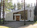
 Pihtipudas Church
 -
 Muurasjärvi Church
 -
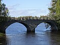 Heinäjoki Bridge


See also
[edit]References
[edit]- ^ a b "Area of Finnish Municipalities 1.1.2018" (PDF). National Land Survey of Finland. Retrieved 30 January 2018.
- ^ a b c "Population growth biggest in nearly 70 years". Population structure. Statistics Finland. 26 April 2024. ISSN 1797-5395. Retrieved 29 April 2024.
- ^ "Population according to age (1-year) and sex by area and the regional division of each statistical reference year, 2003–2020". StatFin. Statistics Finland. Retrieved 2 May 2021.
- ^ a b "Luettelo kuntien ja seurakuntien tuloveroprosenteista vuonna 2023". Tax Administration of Finland. 14 November 2022. Retrieved 7 May 2023.
- ^ "Pihtipudas". Järviwiki. Finland's Environmental Administration. 2012. Retrieved 27 February 2012.
- ^ "Viitasaari - Tietoja Viitasaaresta". viitasaari.fi (in Finnish). Archived from the original on 12 January 2018. Retrieved 2 October 2022.
- ^ "SuomalainenPaikannimikirja_e-kirja_kuvallinen.pdf" (PDF). kaino.kotus.fi (in Finnish). p. 335. Retrieved 2 October 2022.
- ^ Lind, John (1989). Rillankivi and the Oulainen Boundary Marks– Border Stones from the Nöteborg/Orekhovets Peace Treaty (in Finnish ). Helsinki: Suomen Museo. p. 53-79.
- ^ a b c d "Ystäväkuntalista" (PDF) (in Finnish). Pohjola-Norden. Retrieved 7 May 2012.[permanent dead link]
- ^ "Vennskapskommune samarbeide i Norden" (in Icelandic). Borgarbyggð Municipality. Archived from the original on 17 February 2012. Retrieved 7 May 2012.
External links
[edit]![]() Media related to Pihtipudas at Wikimedia Commons
Media related to Pihtipudas at Wikimedia Commons
- Municipality of Pihtipudas – Official website (in Finnish)
Places adjacent to Pihtipudas | |
|---|---|
| Municipalities | ||
|---|---|---|
| Former municipalities | ||
| International | |
|---|---|
| National | |
| Geographic | |
This Western Finland location article is a stub. You can help Wikipedia by expanding it. |