
La Pointe, Wisconsin
La Pointe, Wisconsin | |
|---|---|
Town | |
 | |
 La Pointe  La Pointe | |
| Coordinates: 46°46′45″N 90°47′12″W / 46.77917°N 90.78667°W | |
| Country | |
| State | |
| County | Ashland |
| Area | |
| • Total | 202.4 km2 (78.1 sq mi) |
| • Land | 201.4 km2 (77.8 sq mi) |
| • Water | 1.0 km2 (0.4 sq mi) |
| Elevation | 190 m (610 ft) |
| Population (2020)[1] | |
| • Total | 428 |
| • Density | 2.1/km2 (5.5/sq mi) |
| Time zone | UTC-6 (Central (CST)) |
| • Summer (DST) | UTC-5 (CDT) |
| ZIP code | 54850 |
| Area code(s) | 715 & 534 |
| GNIS feature ID | 1567683[2] |
| GNIS feature ID | 1583529[3] |
| Website | townoflapointewi |

La Pointe is a town in Ashland County, Wisconsin, United States. The town includes all of the Apostle Islands except for the westernmost four, which lie in the towns of Bayfield and Russell in Bayfield County.
While the area encompassing the Town of La Pointe is made up of the entire Apostle Islands archipelago, the residents of the community live on the western shore of Madeline Island, the largest of the Apostle Islands because it is the only Apostle Island open to commercial development.[4] The population was 428 at the 2020 census.[5] Downtown La Pointe is adjacent to the Madeline Island Ferry dock. Neighborhoods include Middleport and Old Fort. La Pointe has a post office with ZIP code 54850.[6] Its name in the Anishinaabe language is Mooningwanekaaning, meaning "The Home of the Golden Breasted Woodpecker".
Geography[edit]
According to the United States Census Bureau, the town has a total area of 78.0 square miles (202 km2), of which, 77.6 square miles (201 km2) of it is land and 0.4 square miles (1.0 km2) of it (0.50%) is water.
Madeline Island is part of the Town of La Pointe.[7] County Highway H serves as a main route. Nearby is Chequamegon Bay, an inlet of Lake Superior.
History[edit]
According to William Whipple Warren's History of the Ojibway People (18xx), Moningwunakuaning "is the spot on which the Ojibway tribe first grew, and like a tree it has spread its branches in every direction, in the bands that now [1885] occupy the vast extent of the Ojibway earth; and also that 'it is the root from which all the far scattered villages of the tribe have sprung.'"[8]
La Pointe was originally the site of a fortified French trading post from 1693 to 1698 and from 1718 to 1759. The current city began to develop in the late 18th century as an American Fur Company outpost under the leadership of Michel Cadotte.[9][citation needed]
Warren, whose mother was French-Ojibwa, learned from maternal tribal elders that the Ojibwa originally lived near the mouth of the St. Lawrence River. At the time of great sickness and death, the Great Spirit interceded through Manabosho, a common uncle of the Anishinubag (spontaneous people). Through the discovery of the snakeroot they were granted the rite, enabled through their Medawe (religion), "wherewith life is restored and prolonged." The great Megis (seashell) showed itself as a glossy thing reflecting on the sea. It led them first to a place near Montreal where they stayed for some time. Next it led them to Boweting (Sault Ste. Marie); again they stayed for some time. At last it led them to Moningwunakauning (La Pointe, Madeline Island), "where it has ever since reflected back the rays of the sun, and blessed our ancestors with life, light and wisdom," says Warren. So the flickering shaft of light is the Megis, and La Pointe is the center of the Earth for the Ojibwa.
Kechewaishke, commonly known as Chief Buffalo, was an Ojibwa leader born at La Pointe in 1759. Recognized as the principal chief of the Lake Superior Chippewa (Ojibwa)[10] for nearly a half-century until his death in 1855, he led his nation into a treaty relationship with the United States Government, signing treaties in 1825, 1826, 1837, 1842, 1847, and 1854. He was also instrumental in resisting the efforts of the United States to remove the Ojibwa and in securing permanent reservations for his people near Lake Superior.
Licensed Indian traders operated at this location and nearby stores at Lac Courte Oreilles Reservation and other convenient places.[11]
Today, the town's history is preserved at Madeline Island Historical Museum.[12]
Demographics[edit]

2020 census[edit]
As of the census of 2020,[1] the population was 428. The population density was 5.5 inhabitants per square mile (2.1/km2). There were 848 housing units at an average density of 10.9 per square mile (4.2/km2). The racial makeup of the town was 88.1% White, 3.5% Black or African American, 1.4% Native American, 0.7% from other races, and 6.3% from two or more races. Ethnically, the population was 1.6% Hispanic or Latino of any race.
2000 census[edit]
As of the census[13][Link to precise page] of 2000, there were 246 people, 125 households, and 66 families residing in the town. The population density was 3.2 people per square mile (1.2 people/km2). There were 692 housing units at an average density of 8.9 per square mile (3.4/km2). The racial makeup of the town was 94.72% White, 1.63% Native American, 0.41% Pacific Islander, 0.41% from other races, and 2.85% from two or more races. Hispanic or Latino of any race were 0.41% of the population.
There were 125 households, out of which 22.4% had children under the age of 18 living with them, 44.0% were married couples living together, 4.8% had a female householder with no husband present, and 46.4% were non-families. 40.8% of all households were made up of individuals, and 13.6% had someone living alone who was 65 years of age or older. The average household size was 1.96 and the average family size was 2.64.
In the town, the population was spread out, with 19.1% under the age of 18, 2.8% from 18 to 24, 24.4% from 25 to 44, 34.1% from 45 to 64, and 19.5% who were 65 years of age or older. The median age was 46 years. For every 100 females, there were 119.6 males. For every 100 females age 18 and over, there were 116.3 males.
The median income for a household in the town was $33,500, and the median income for a family was $42,708. Males had a median income of $29,583 versus $31,042 for females. The per capita income for the town was $23,352. None of the families and 4.6% of the population were living below the poverty line, including no under eighteens and 2.1% of those over 64.
Government[edit]
Local government[edit]
La Pointe is governed by an elected five-person board of supervisors and an appointed town administrator, along with several boards of volunteers;[14] in addition, some decisions are made by the voters directly through town meetings.[15] As of June 2021,[update] the town administrator is Lisa Potswald,[16] the chair of the board of supervisors is Glenn Carlson (term on board ends 2023), and the board's other members are Aimee Baxter (term on board ends 2023), John Carlson (2023)[needs update], Mike Anderson (2022), and Sue Brenna (2022)[needs update].[15]
The town employs a police and fire department and has a public library and elementary school; from sixth grade on, students attend school in Bayfield.[14]
Federal and state representation[edit]
La Pointe is in Wisconsin's 7th congressional district, represented by Tom Tiffany (R); the 25th Wisconsin State Senate district, represented by Romaine Quinn (R); and the 74th Wisconsin State Assembly district, represented by Chanz Green (R).
Tourism[edit]
Tourism makes up a large part of the local economy. La Pointe, like Bayfield (on the mainland), has become a popular tourist destination during the summer, when many local events are scheduled.[17]
Downtown La Pointe offers many bars, restaurants, and other amenities. These include indigenous restaurant Miijim, whose owner and chef, Bryce Stevenson, was a 2024 semifinalist for the James Beard Foundation's national award for emerging chef.[18] Camping, swimming, hiking, and other outdoor recreational activities are abundant and popular on the island.[19]
Travel[edit]

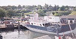
Madeline Island and the town of La Pointe are accessible by the Madeline Island Ferry line.[20] The steel-hulled car/passenger ferries depart from Bayfield on a set schedule. Many attractions on the island are within walking distance of the ferry dock, such as the museum and library. It may be necessary to bring a vehicle to reach attractions that are farther away, such as Big Bay State Park. County Highway H serves as a main route in the community.
There is also a public boat marina near the ferry dock.[21]
Ground transportation to the island during the winter (late December through February) is by way of an ice road, which is open when ice levels are safe enough for vehicles to pass.[21]
The Major Gilbert Field Airport (FAA LID: 4R5) is a general aviation airport that features a 3,000-foot by 75-foot landing strip, as well as overnight tie-downs and an array of other services. The airport is publicly-owned by the Town of La Pointe.[22]
Notable people[edit]
- Kechewaishke, Native American leader
- Michel Cadotte, prominent fur trader
- Ozhaguscodaywayquay, noted Native American businesswoman
- Thomas D. O'Brien, Justice of the Minnesota Supreme Court
- William Whipple Warren, Minnesota Territory legislator
Gallery[edit]
-
 Vehicles loading onto the Madeline Island ferry boat
 -
 The Island Queen ferry boat
 -
 Madeline Island ferry boat
 -
 Headstone of Great Buffalo, in the La Pointe Indian Cemetery.


See also[edit]
References[edit]
- ^ a b "2020 Decennial Census: La Pointe town, Ashland County, Wisconsin". data.census.gov. U.S. Census Bureau. Retrieved July 15, 2022.
- ^ U.S. Geological Survey Geographic Names Information System: La Pointe, Wisconsin
- ^ "US Board on Geographic Names". United States Geological Survey. October 25, 2007. Retrieved January 31, 2008.
- ^ Madelineisland.com Archived September 29, 2011, at the Wayback Machine
- ^ "2020 Decennial Census: La Pointe town, Ashland County, Wisconsin". data.census.gov. U.S. Census Bureau. Retrieved July 15, 2022.
- ^ ZIP Code Lookup
- ^ "Town of La Pointe". Madeline Island Chamber of Commerce. June 13, 2011. Archived from the original on June 4, 2021. Retrieved June 4, 2021.
- ^ Warren, William Whipple. (1885). History of the Ojibways : based upon traditions and oral statements. Saint Paul, Minn.: Minnesota Historical Society. Series: Collections of the Minnesota Historical Society, v. 5. pp. 79-81. Library of Congress website Retrieved March 17, 2020.
- ^ Madelineisland.com Archived September 29, 2011, at the Wayback Machine [dead link]
- ^ Although the original term Ojibwe as "Ojibwa" is now preferred to its English corruption "Chippewa," Chippewa has historically been the dominant English usage, was used in treaties with the United States, and remains part of the official name of many tribal groups: Lake Superior Chippewa, Red Cliff Chippewa, etc.
- ^ United States Senate. (1888-1889) Congressional Serial Set. Reports of the Committees of the Senate of the U.S. Second Session of the Fiftieth Congress. Washington, DC: Government Printing Office. p 175. Google Books Retrieved March 14, 2020.
- ^ State Historical Society
- ^ "U.S. Census website". United States Census Bureau. Retrieved January 31, 2008.
- ^ a b "Town of La Pointe". Madeline Island Chamber of Commerce. June 13, 2011. Archived from the original on June 4, 2021. Retrieved June 4, 2021.
- ^ a b "Town Board". Town of La Pointe. Archived from the original on June 4, 2021. Retrieved June 4, 2021.
- ^ "Town Staff". Town of La Pointe. Archived from the original on June 4, 2021. Retrieved June 4, 2021.
- ^ "Madeline Island Chamber of Commerce - Lake Superior Vacation & Visitor Information". Archived from the original on August 20, 2011. Retrieved August 24, 2011.
- ^ "The 2024 James Beard Awards Semifinalists | James Beard Foundation". www.jamesbeard.org. Retrieved January 25, 2024.
- ^ "Madeline Island – Lodging, Shopping, Real Estate, Dining, Services, Entertainment and Attractions". Archived from the original on August 20, 2011. Retrieved August 24, 2011.
- ^ "Madeline Island Ferry Line - Ferry Boat from Bayfield WI to LaPointe WI". Madeline Island Ferry Line. Retrieved January 23, 2023.
- ^ a b "Lake Superior Vacations on Madeline Island in Chequamegon Bay at the Northern Tip of the Bayfield Peninsula". Archived from the original on August 19, 2011. Retrieved August 24, 2011.
- ^ "Airport Info". www.4r5.org. Retrieved July 12, 2021.
External links[edit]
- Jalbert, Andrew J. Schooner Lucerne: Lessons from a Great Lakes Shipwreck (July 27, 2007) SEA HISTORY magazine, The Wreck of the Schooner Lucerne.
- Official website for the Town of La Pointe
- Madeline Island Chamber of Commerce
- Madeline Island from Wisconsin Historical Society
- Madeline Island Ferry Line
- Big Bay State Park

Municipalities and communities of Ashland County, Wisconsin, United States | ||
|---|---|---|
| Cities |  | |
| Village | ||
| Towns | ||
| CDPs | ||
| Other communities | ||
| Indian reservation | ||
| Footnotes | ‡This populated place also has portions in an adjacent county or counties | |
| International | |
|---|---|
| National | |
| Other | |