Jabal al-Druze
This article includes a list of general references, but it lacks sufficient corresponding inline citations. (May 2016) |

| Part of a series on
Druze |
|---|
 |
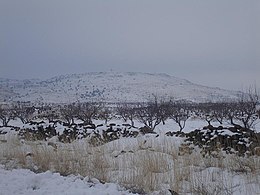
Jabal al-Druze (Arabic: جبل الدروز, romanized: jabal al-durūz, lit. 'Mountain of the Druze'), is an elevated volcanic region in the As-Suwayda Governorate of southern Syria.[1] Most of the inhabitants of this region are Druze, and there are also significant Christian communities.[2][3] Safaitic inscriptions were first found in this area. The State of Jabal Druze was an autonomous area in the French Mandate for Syria and the Lebanon from 1921 to 1936.[4][5] In the past, the name Jabal al-Druze was used for a different area, located in Mount Lebanon.[citation needed]
As of 2024 the Druze still aspire for independence and forming their own country and home in south Syria.[6]During the civil war, the Druze community declined to take sides leading the regime to terrorize the population and engage in de facto ethnic cleansing. As a result, tens of thousands have fled the Sawayda region.Cite error: A <ref> tag is missing the closing </ref> (see the help page).
In the 1980s Druze made up 87.6% of the population, Christians (mostly Greek Orthodox) 11% and Sunni Muslims 2%.[7] In 2010, the As-Suwayda governorate has a population of about 375,000 inhabitants, Druze made up 90%, Christians 7% and Sunni Muslims 3%.[2] Due to low birth and high emigration rates, Christians proportion in As-Suwayda had declined.[2]
Geology
[edit]
The Jabal al-Druze volcanic field, the southernmost in Syria, lies in the Haurun-Druze Plateau in SW Syria near the border with Jordan. The most prominent feature of this volcanic field is 1800m-high Jabal al-Druze (also known variously as Jabal ad Duruz, Djebel Al-Arab, Jabal Druze, Djebel ed Drouz). The alkaline volcanic field consists of a group of 118 basaltic volcanoes active from the lower-Pleistocene to the Holocene (2.6 million years ago to present). The large SW Plateau depression is filled by basaltic lava flows from volcanoes aligned in a NW-SE direction. This volcanic field lies within the northern part of the massive alkaline Harrat al-Sham (also known as Harrat al-Shaam) volcanic field that extends from southern Syria to Saudi Arabia.[8]
Peaks
[edit]- Tell Qeni (1,803 m)
- Tell Joualine (1,732 m)
- Tell Sleiman (1,703 m)
- Tell Qleib (1,698 m)
- Tell Abou-Hamra (1,482 m)
- Tell El-Ahmar (1,452 m)
- Tell Abed-Mar (1,436 m)
- Tell Khodr-Imtan (1,341 m)
- Tell Azran (1,220 m)
- Tell Shihan (1,138 m)
In Arabic, the word "tell" means "mound" or "hill", but in Jabal al-Druze it rather refers to a volcanic cone.
See also
[edit]References
[edit]- ^ "Mount al-Durūz | Lebanon, Anti-Lebanon Range, Summit | Britannica". www.britannica.com. Retrieved 2024-07-22.
- ^ a b c The Druze and Assad: Strategic Bedfellows
- ^ "Christians in Syria's Suwayda discuss history, coexistence with Druze majority". North Press. 18 September 2020.
- ^ "11. French Syria (1919-1946)". uca.edu. Retrieved 2024-07-22.
- ^ "French Mandate for Syria and the Lebanon". The American Journal of International Law. 17 (3): 177–182. 1923. doi:10.2307/2212963. ISSN 0002-9300. JSTOR 2212963.
- ^ Merlin, Ohad (July 20, 2024). "'I dream of liberated Druze land for brethren in Syria' - One activist's national aspirations". The Jerusalem Post. Retrieved July 19, 2024.
- ^ Pipes, Daniel (1990). Greater Syria: The History of an Ambition. Oxford University Press. p. 151. ISBN 978-0-19-506021-8.
- ^ Krienitz, M.-S.; Haase, K. M.; Mezger, K.; Shaikh-Mashail, M. A. (August 2007). "Magma Genesis and Mantle Dynamics at the Harrat Ash Shamah Volcanic Field (Southern Syria)". Journal of Petrology. 48 (8). Oxford University Press: 1513–1542. doi:10.1093/petrology/egm028. Retrieved 2024-07-22.
